| http://dbpedia.org/ontology/abstract
|
鄭和群礁(英語:Tizard Bank;越南语:Cụm Nam Yết)是位於南沙群島北部的第四列環礁,在道明群礁正南方。由太平島、中灘、中洲礁、敦謙沙洲、舶蘭礁、安達礁、鴻庥島、南薰礁等組成,是南沙群島最大的群礁。
, Die Tizard-Bank, chinesisch 郑和群礁, Pinyin Z … Die Tizard-Bank, chinesisch 郑和群礁, Pinyin Zhènghé Qúnjiāo, vietnamesisch Trịnh Hoà quần tiêu, ist ein großes, teilweise versunkenes Atoll im nördlichen Bereich der Spratly-Inseln. Die westliche Bezeichnung Tizard-Bank ist benannt nach dem englischen Ozeanographen Thomas Henry Tizard (1839–1924).nographen Thomas Henry Tizard (1839–1924).
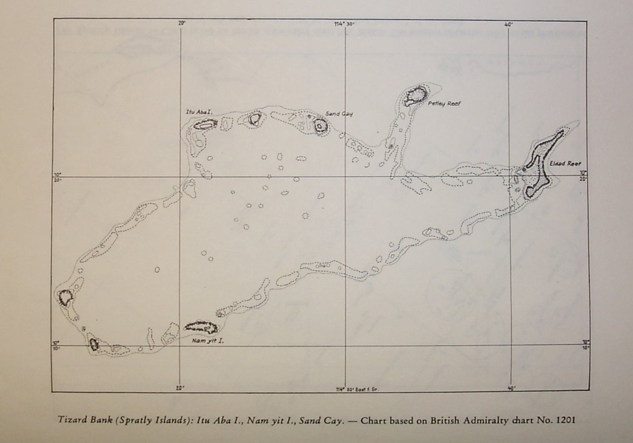
, The Tizard Bank, 10°15′N 114°30′E / 10.2 … The Tizard Bank, 10°15′N 114°30′E / 10.250°N 114.500°E is a partially sunken atoll and one of the significant maritime features of the north-western part of the Spratly Islands. It is claimed by the People's Republic of China, the Republic of China, and Vietnam, and various parts of it are occupied by these states. It was named after Thomas Henry Tizard (1839 – 17 February 1924), a British oceanographer and surveyor who surveyed the bank from aboard HMS Rifleman in the 1860s. In 1947 the Republic of China government gave the bank the name Zheng He Archipelago after the famous Ming-era admiral, although there is no evidence that he ever visited Tizard Bank. From before the 1870s the islands were used by fishermen from Hainan with Itu Aba Island having a semi-permanent settlement of Chinese fishermen. The bank rises steeply from surrounding depths ranging from 500 to 700 meters. It is 32.05 nautical miles (59.36 km; 36.88 mi) in length, and extends west from the Gaven Reefs to the NW of Dangerous Ground. The atoll is up to 11.36 nautical miles (21.04 km; 13.07 mi) wide. The total area is 953 square kilometres (368 sq mi), and the greatest depth of the central lagoon is 80 meters. The central lagoon generally is 10 to 40 meters deep, although many coral heads have much shallower depths. There are several entrances into the lagoon. The bank contains a number of features along the rim of the reef, including shoals, reefs, islands, and cays, numerous wrecks, some lighthouses, and an ammunition dumping ground in about 2000m of water to the north of Itu Aba. Several coral heads with depths of 6-12m lie in the lagoon, and depths "3.7m less than charted can be expected. ... Mariners should navigate with extreme caution in this vicinity." Features in the area include:
* Namyit Island (10°11'N 114°22'E) on the S side of the bank is about 12 miles S of Itu Aba. It is less than a metre high and covered with small trees and brush.
* Gaven Reefs (10°12'N 114°13'E) consists of two reefs which cover at high tide and lie 7 miles W and 8.5 miles WNW of Namyit Island.
* Itu Aba Island (10°23'N 114°22'E), lies on the NW edge of the bank
* Zhongzhou Reef (Ban Than Reef / Centre Cay) lies on the north edge between Itu Aba and Sand Cay, 3 miles E of Itu Aba
* Sand Cay lies on the north edge, 4.5 miles E of Zhongzhou
* Petley Reef, which dries 0.9m, is about 1 mile in extent and lies on the N side of the bank.
* , 7 miles ESE of Petley Reef, is the easternmost drying reef of the group. The reef is 4.5 miles long with the middle section having a depth of about 1.2m, located at the NE end of the reef. Xiao Nanxun Jiao(Gaven Reef South)Nanxun Jiao(Gaven Reef)Taiping Dao(Itu Aba)Zhongzhou JiaoĐảo Sơn Ca(Sand Cay)Đá Núi Thị(Petley Reef)(Eldad Reef)Đảo Nam Yết(Namyit) It is neighboured by the Loaita Bank to the North, Discovery Great Reef to the west, and the Union Banks to the south.he west, and the Union Banks to the south.
, ティザード堆(ティザードたい、英語:Tizard Bank、中国語: 鄭和群礁(簡体 … ティザード堆(ティザードたい、英語:Tizard Bank、中国語: 鄭和群礁(簡体字中国語: 郑和群礁))は、南シナ海の南沙諸島北部にある環礁である。主として暗礁等から成り、高潮時にも水面上にあるのは南沙諸島最大の島であるイツアバ島(太平島)のみである。 英国の発行する海図には、1860年代にこの環礁を調査した英国の海洋学者に因んで"Tizard Bank"と表記している。中国名の鄭和群礁は、南海を航海した明代の武将鄭和に因むものである。またアメリカ国家地球空間情報局が発行する海図には、鄭和群礁をピンイン表記した"ZHENGHE QUNJIAO"と丸括弧書きで"Southhampton Reefs"と併記している。 ティザード堆の島礁については、中華人民共和国、中華民国(台湾)、ベトナム、フィリピンが主権を主張している。 エルダド礁やガベン礁では中国による埋め立てが確認されている。が主権を主張している。 エルダド礁やガベン礁では中国による埋め立てが確認されている。
|
| http://dbpedia.org/ontology/thumbnail
|
http://commons.wikimedia.org/wiki/Special:FilePath/Tizard_Bank%2C_Spratly_Islands.png?width=300 +
|
| http://dbpedia.org/ontology/wikiPageExternalLink
|
http://www.spratlys.org/maps/2/tizard_bank.jpg +
|
| http://dbpedia.org/ontology/wikiPageID
|
40530621
|
| http://dbpedia.org/ontology/wikiPageLength
|
5962
|
| http://dbpedia.org/ontology/wikiPageRevisionID
|
1050986418
|
| http://dbpedia.org/ontology/wikiPageWikiLink
|
http://dbpedia.org/resource/Zhongzhou_Reef +
, http://dbpedia.org/resource/Republic_of_China_%281912%E2%80%931949%29 +
, http://dbpedia.org/resource/Loaita_Bank +
, http://dbpedia.org/resource/Gaven_Reefs +
, http://dbpedia.org/resource/Category:Banks_of_the_Spratly_Islands +
, http://dbpedia.org/resource/List_of_maritime_features_in_the_Spratly_Islands +
, http://dbpedia.org/resource/Hainan +
, http://dbpedia.org/resource/Itu_Aba_Island +
, http://dbpedia.org/resource/Thomas_Henry_Tizard +
, http://dbpedia.org/resource/Sand_Cay +
, http://dbpedia.org/resource/Atoll +
, http://dbpedia.org/resource/Dangerous_Ground_%28Spratly_Islands%29 +
, http://dbpedia.org/resource/Gaven_Reef +
, http://dbpedia.org/resource/Union_Banks +
, http://dbpedia.org/resource/Taiwan +
, http://dbpedia.org/resource/Zheng_He +
, http://dbpedia.org/resource/Itu_Aba +
, http://dbpedia.org/resource/Petley_Reef +
, http://dbpedia.org/resource/Vietnam +
, http://dbpedia.org/resource/Discovery_Great_Reef +
, http://dbpedia.org/resource/File:00-149_Tizard_Bank_Spratly_Islands.png +
, http://dbpedia.org/resource/China +
, http://dbpedia.org/resource/Namyit_Island +
, http://dbpedia.org/resource/Category:Tizard_Bank +
, http://dbpedia.org/resource/Eldad_Reef +
, http://dbpedia.org/resource/Lagoon +
|
| http://dbpedia.org/property/scale
|
630
|
| http://dbpedia.org/property/text
|
http://dbpedia.org/resource/Petley_Reef +
, http://dbpedia.org/resource/Eldad_Reef +
, http://dbpedia.org/resource/Itu_Aba +
, http://dbpedia.org/resource/Zhongzhou_Reef +
, http://dbpedia.org/resource/Sand_Cay +
, http://dbpedia.org/resource/Gaven_Reef +
, http://dbpedia.org/resource/Namyit_Island +
|
| http://dbpedia.org/property/width
|
630
|
| http://dbpedia.org/property/wikiPageUsesTemplate
|
http://dbpedia.org/resource/Template:Image_label +
, http://dbpedia.org/resource/Template:Spratly_Islands_topics +
, http://dbpedia.org/resource/Template:Reflist +
, http://dbpedia.org/resource/Template:South_China_Sea +
, http://dbpedia.org/resource/Template:Clear +
, http://dbpedia.org/resource/Template:Convert +
, http://dbpedia.org/resource/Template:Image_label_end +
, http://dbpedia.org/resource/Template:Coord +
, http://dbpedia.org/resource/Template:Image_label_begin +
|
| http://dbpedia.org/property/x
|
1100
, 130
, 480
, 500
, 660
, 1020
, 40
, 215
|
| http://dbpedia.org/property/y
|
300
, 560
, 670
, 160
, 50
, 745
, 230
, 110
|
| http://purl.org/dc/terms/subject
|
http://dbpedia.org/resource/Category:Tizard_Bank +
, http://dbpedia.org/resource/Category:Banks_of_the_Spratly_Islands +
|
| http://www.georss.org/georss/point
|
10.25 114.5
|
| http://www.w3.org/2003/01/geo/wgs84 pos#geometry
|
POINT(114.5 10.25)
|
| http://www.w3.org/2003/01/geo/wgs84 pos#lat
|
10.25
|
| http://www.w3.org/2003/01/geo/wgs84 pos#long
|
114.5
|
| http://www.w3.org/ns/prov#wasDerivedFrom
|
http://en.wikipedia.org/wiki/Tizard_Bank?oldid=1050986418&ns=0 +
|
| http://xmlns.com/foaf/0.1/depiction
|
http://commons.wikimedia.org/wiki/Special:FilePath/Tizard_Bank%2C_Spratly_Islands.png +
, http://commons.wikimedia.org/wiki/Special:FilePath/00-149_Tizard_Bank_Spratly_Islands.png +
|
| http://xmlns.com/foaf/0.1/isPrimaryTopicOf
|
http://en.wikipedia.org/wiki/Tizard_Bank +
|
| owl:sameAs |
http://rdf.freebase.com/ns/m.012krrst +
, http://vi.dbpedia.org/resource/C%E1%BB%A5m_Nam_Y%E1%BA%BFt +
, http://dbpedia.org/resource/Tizard_Bank +
, http://de.dbpedia.org/resource/Tizard-Bank +
, https://global.dbpedia.org/id/t1G1 +
, http://zh.dbpedia.org/resource/%E9%83%91%E5%92%8C%E7%BE%A4%E7%A4%81 +
, http://yago-knowledge.org/resource/Tizard_Bank +
, http://ja.dbpedia.org/resource/%E3%83%86%E3%82%A3%E3%82%B6%E3%83%BC%E3%83%89%E5%A0%86 +
, http://www.wikidata.org/entity/Q19646448 +
|
| rdf:type |
http://www.w3.org/2003/01/geo/wgs84_pos#SpatialThing +
|
| rdfs:comment |
Die Tizard-Bank, chinesisch 郑和群礁, Pinyin Z … Die Tizard-Bank, chinesisch 郑和群礁, Pinyin Zhènghé Qúnjiāo, vietnamesisch Trịnh Hoà quần tiêu, ist ein großes, teilweise versunkenes Atoll im nördlichen Bereich der Spratly-Inseln. Die westliche Bezeichnung Tizard-Bank ist benannt nach dem englischen Ozeanographen Thomas Henry Tizard (1839–1924).nographen Thomas Henry Tizard (1839–1924).
, ティザード堆(ティザードたい、英語:Tizard Bank、中国語: 鄭和群礁(簡体 … ティザード堆(ティザードたい、英語:Tizard Bank、中国語: 鄭和群礁(簡体字中国語: 郑和群礁))は、南シナ海の南沙諸島北部にある環礁である。主として暗礁等から成り、高潮時にも水面上にあるのは南沙諸島最大の島であるイツアバ島(太平島)のみである。 英国の発行する海図には、1860年代にこの環礁を調査した英国の海洋学者に因んで"Tizard Bank"と表記している。中国名の鄭和群礁は、南海を航海した明代の武将鄭和に因むものである。またアメリカ国家地球空間情報局が発行する海図には、鄭和群礁をピンイン表記した"ZHENGHE QUNJIAO"と丸括弧書きで"Southhampton Reefs"と併記している。 ティザード堆の島礁については、中華人民共和国、中華民国(台湾)、ベトナム、フィリピンが主権を主張している。 エルダド礁やガベン礁では中国による埋め立てが確認されている。が主権を主張している。 エルダド礁やガベン礁では中国による埋め立てが確認されている。
, 鄭和群礁(英語:Tizard Bank;越南语:Cụm Nam Yết)是位於南沙群島北部的第四列環礁,在道明群礁正南方。由太平島、中灘、中洲礁、敦謙沙洲、舶蘭礁、安達礁、鴻庥島、南薰礁等組成,是南沙群島最大的群礁。
, The Tizard Bank, 10°15′N 114°30′E / 10.2 … The Tizard Bank, 10°15′N 114°30′E / 10.250°N 114.500°E is a partially sunken atoll and one of the significant maritime features of the north-western part of the Spratly Islands. It is claimed by the People's Republic of China, the Republic of China, and Vietnam, and various parts of it are occupied by these states. From before the 1870s the islands were used by fishermen from Hainan with Itu Aba Island having a semi-permanent settlement of Chinese fishermen. Features in the area include:e fishermen. Features in the area include:
|
| rdfs:label |
Tizard Bank
, 郑和群礁
, Tizard-Bank
, ティザード堆
|