| http://dbpedia.org/ontology/abstract
|
O Rio Comal é o rio navegável mais curto d … O Rio Comal é o rio navegável mais curto do estado do Texas, Estados Unidos. Proclamado como o "maior rio mais curto do mundo" pelos habitantes locais, ele corre inteiramente dentro dos limites da cidade de New Braunfels no sudeste do Condado de Comal. É um afluente do . O Comal começa em em e anda 2,5 milhas (4 km) até o seu entroncamento com o Guadalupe.) até o seu entroncamento com o Guadalupe.
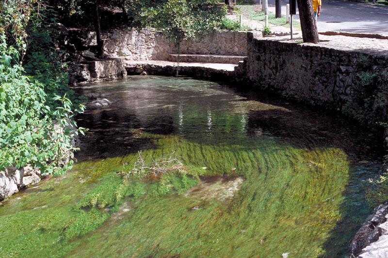
, The Comal River (/ˈkoʊmæl/ KOH-mal) is the … The Comal River (/ˈkoʊmæl/ KOH-mal) is the shortest navigable river in the state of Texas in the United States. Proclaimed the "longest shortest river in the world" by locals, it runs entirely within the city limits of New Braunfels in southeast Comal County. It is a tributary of the Guadalupe River. The Comal begins at Comal Springs in Landa Park and flows 2.5 miles (4.0 km) until its junction with the Guadalupe. The Comal was originally called the Little Guadalupe in early Spanish accounts. After Spaniard Pedro de Rivera y Villalón identified the longer river as the Guadalupe in 1727, the Comal was given its current name. The name means basin or flat dish in Spanish. Historically, the Comal was used to power watermills and cotton gins by early German settlers, and later to provide hydroelectric power. The river is primarily used for water recreation today, being the location of the original Schlitterbahn water amusement park. The water is administered by the Guadalupe-Blanco River Authority. The river is also one of only two rivers to host the fountain darter, a fish now in danger of extinction. The only other river inhabited by the darter is the nearby San Marcos River.the darter is the nearby San Marcos River.
, Le Comal est le cours d'eau le moins long … Le Comal est le cours d'eau le moins long du Texas ; il ne s'étend que de la ville de New Braunfels au sud-ouest du comté de Comal. C'est le tributaire de la Guadalupe River. Le Comal commence à Comal Springs à Landa Park et s'écoule sur une distance de 4 km (2.5 mi) jusqu'à ce qu'il joigne le Guadalupe. Cette rivière s'est d'abord appelée le Guadalupe en espagnol, mais après que Pedro de Rivera y Villalón eut identifié le Guadalupe comme le plus long des deux en 1727, on a donné au Comal son nom actuel. « Comal » signifie « cuvette » ou « plat » en français. Autrefois, on utilisait le Comal pour faire fonctionner des moulins et des égreneuses de coton et plus tard, pour l'hydroélectricité. Aujourd'hui, on utilise ce fleuve plutôt pour la récréation et le sport, et il y eut même un parc de loisirs, le Schlitterbahn. L'eau est sous le contrôle du Guadalupe-Blanco River Authority.trôle du Guadalupe-Blanco River Authority.
|
| http://dbpedia.org/ontology/length
|
4023.36
|
| http://dbpedia.org/ontology/mouthElevation
|
182.88
|
| http://dbpedia.org/ontology/mouthMountain
|
http://dbpedia.org/resource/Comal_County%2C_Texas +
, http://dbpedia.org/resource/New_Braunfels%2C_Texas +
|
| http://dbpedia.org/ontology/mouthPlace
|
http://dbpedia.org/resource/Comal_County%2C_Texas +
, http://dbpedia.org/resource/New_Braunfels%2C_Texas +
|
| http://dbpedia.org/ontology/riverMouth
|
http://dbpedia.org/resource/Guadalupe_River_%28Texas%29 +
|
| http://dbpedia.org/ontology/thumbnail
|
http://commons.wikimedia.org/wiki/Special:FilePath/Schlitterbahn4.jpg?width=300 +
|
| http://dbpedia.org/ontology/wikiPageExternalLink
|
https://tours.fishviews.com/public/comal-river%2343/ +
, http://texashistory.unt.edu/ +
, http://www.gbra.org/ +
, https://web.archive.org/web/20080723155832/http:/texashistory.unt.edu/permalink/meta-pth-5828 +
, http://texashistory.unt.edu/widgets/pager.php%3Fobject_id=meta-pth-5828&recno=69&path=meta-pth-5828.tkl +
, http://www.edwardsaquifer.net/images/1-020.jpg +
|
| http://dbpedia.org/ontology/wikiPageID
|
1371553
|
| http://dbpedia.org/ontology/wikiPageLength
|
5689
|
| http://dbpedia.org/ontology/wikiPageRevisionID
|
1118326024
|
| http://dbpedia.org/ontology/wikiPageWikiLink
|
http://dbpedia.org/resource/River +
, http://dbpedia.org/resource/United_States +
, http://dbpedia.org/resource/Cotton_gins +
, http://dbpedia.org/resource/Spain +
, http://dbpedia.org/resource/Tubing_%28recreation%29 +
, http://dbpedia.org/resource/Guadalupe_River_%28Texas%29 +
, http://dbpedia.org/resource/New_Braunfels%2C_Texas +
, http://dbpedia.org/resource/Water_sport_%28recreation%29 +
, http://dbpedia.org/resource/San_Marcos_River +
, http://dbpedia.org/resource/Fountain_darter +
, http://dbpedia.org/resource/Rapids +
, http://dbpedia.org/resource/Category:Rivers_of_Comal_County%2C_Texas +
, http://dbpedia.org/resource/Category:Guadalupe_River_%28Texas%29 +
, http://dbpedia.org/resource/Category:Rivers_of_Texas +
, http://dbpedia.org/resource/Texas +
, http://dbpedia.org/resource/Guadalupe-Blanco_River_Authority +
, http://dbpedia.org/resource/Hydroelectricity +
, http://dbpedia.org/resource/Category:New_Braunfels%2C_Texas +
, http://dbpedia.org/resource/Watermills +
, http://dbpedia.org/resource/List_of_rivers_of_Texas +
, http://dbpedia.org/resource/Germany +
, http://dbpedia.org/resource/Comal_County%2C_Texas +
, http://dbpedia.org/resource/Comal_Springs +
, http://dbpedia.org/resource/Comal_Springs_%28Texas%29 +
, http://dbpedia.org/resource/Scuba_diving +
, http://dbpedia.org/resource/Spanish_language +
, http://dbpedia.org/resource/Schlitterbahn +
|
| http://dbpedia.org/property/id
|
rnc11
|
| http://dbpedia.org/property/imageCaption
|
The Comal River as it runs past Schlitterbahn water park.
|
| http://dbpedia.org/property/mapCaption
|
Location of the Comal River
|
| http://dbpedia.org/property/mapSize
|
250
|
| http://dbpedia.org/property/mouth
|
http://dbpedia.org/resource/Guadalupe_River_%28Texas%29 +
|
| http://dbpedia.org/property/mouthLocation
|
http://dbpedia.org/resource/Comal_County%2C_Texas +
, http://dbpedia.org/resource/New_Braunfels%2C_Texas +
|
| http://dbpedia.org/property/name
|
Comal River
|
| http://dbpedia.org/property/pushpinMapSize
|
250
|
| http://dbpedia.org/property/source
|
http://dbpedia.org/resource/Comal_Springs +
|
| http://dbpedia.org/property/source1Location
|
http://dbpedia.org/resource/New_Braunfels%2C_Texas +
, http://dbpedia.org/resource/Comal_County%2C_Texas +
|
| http://dbpedia.org/property/subdivisionName
|
http://dbpedia.org/resource/United_States +
, http://dbpedia.org/resource/Texas +
|
| http://dbpedia.org/property/subdivisionType
|
Country
, State
|
| http://dbpedia.org/property/wikiPageUsesTemplate
|
http://dbpedia.org/resource/Template:Short_description +
, http://dbpedia.org/resource/Template:Respell +
, http://dbpedia.org/resource/Template:Reflist +
, http://dbpedia.org/resource/Template:Citation_needed +
, http://dbpedia.org/resource/Template:Infobox_river +
, http://dbpedia.org/resource/Template:IPAc-en +
, http://dbpedia.org/resource/Template:Coord +
, http://dbpedia.org/resource/Template:Convert +
, http://dbpedia.org/resource/Template:Commons_category +
, http://dbpedia.org/resource/Template:Authority_control +
, http://dbpedia.org/resource/Template:Handbook_of_Texas +
|
| http://purl.org/dc/terms/subject
|
http://dbpedia.org/resource/Category:Rivers_of_Texas +
, http://dbpedia.org/resource/Category:New_Braunfels%2C_Texas +
, http://dbpedia.org/resource/Category:Rivers_of_Comal_County%2C_Texas +
, http://dbpedia.org/resource/Category:Guadalupe_River_%28Texas%29 +
|
| http://purl.org/linguistics/gold/hypernym
|
http://dbpedia.org/resource/River +
|
| http://www.georss.org/georss/point
|
29.71295 -98.1375
|
| http://www.w3.org/2003/01/geo/wgs84 pos#geometry
|
POINT(-98.137496948242 29.712949752808)
|
| http://www.w3.org/2003/01/geo/wgs84 pos#lat
|
29.712949752808
|
| http://www.w3.org/2003/01/geo/wgs84 pos#long
|
-98.137496948242
|
| http://www.w3.org/ns/prov#wasDerivedFrom
|
http://en.wikipedia.org/wiki/Comal_River?oldid=1118326024&ns=0 +
|
| http://xmlns.com/foaf/0.1/depiction
|
http://commons.wikimedia.org/wiki/Special:FilePath/Schlitterbahn4.jpg +
, http://commons.wikimedia.org/wiki/Special:FilePath/TXMap-doton-NewBraunfels.png +
|
| http://xmlns.com/foaf/0.1/isPrimaryTopicOf
|
http://en.wikipedia.org/wiki/Comal_River +
|
| http://xmlns.com/foaf/0.1/name
|
Comal River
|
| owl:sameAs |
http://sws.geonames.org/4682695/ +
, http://vi.dbpedia.org/resource/S%C3%B4ng_Comal +
, http://pt.dbpedia.org/resource/Rio_Comal +
, http://www.wikidata.org/entity/Q4528528 +
, https://global.dbpedia.org/id/4CDC7 +
, http://dbpedia.org/resource/Comal_River +
, http://fr.dbpedia.org/resource/Comal_%28fleuve%29 +
, http://rdf.freebase.com/ns/m.04xhj0 +
, http://ceb.dbpedia.org/resource/Comal_River +
, http://yago-knowledge.org/resource/Comal_River +
|
| rdf:type |
http://dbpedia.org/ontology/Location +
, http://www.wikidata.org/entity/Q4022 +
, http://www.wikidata.org/entity/Q47521 +
, http://dbpedia.org/class/yago/PhysicalEntity100001930 +
, http://umbel.org/umbel/rc/Stream +
, http://dbpedia.org/class/yago/Thing100002452 +
, http://dbpedia.org/class/yago/BodyOfWater109225146 +
, http://dbpedia.org/ontology/NaturalPlace +
, http://umbel.org/umbel/rc/River +
, http://umbel.org/umbel/rc/BodyOfWater +
, http://schema.org/Place +
, http://dbpedia.org/ontology/BodyOfWater +
, http://dbpedia.org/class/yago/WikicatRiversOfTexas +
, http://schema.org/BodyOfWater +
, http://www.w3.org/2003/01/geo/wgs84_pos#SpatialThing +
, http://dbpedia.org/ontology/River +
, http://dbpedia.org/class/yago/Stream109448361 +
, http://dbpedia.org/class/yago/River109411430 +
, http://dbpedia.org/ontology/Place +
, http://dbpedia.org/ontology/Stream +
, http://schema.org/RiverBodyOfWater +
, http://dbpedia.org/class/yago/YagoGeoEntity +
, http://dbpedia.org/class/yago/YagoPermanentlyLocatedEntity +
|
| rdfs:comment |
O Rio Comal é o rio navegável mais curto d … O Rio Comal é o rio navegável mais curto do estado do Texas, Estados Unidos. Proclamado como o "maior rio mais curto do mundo" pelos habitantes locais, ele corre inteiramente dentro dos limites da cidade de New Braunfels no sudeste do Condado de Comal. É um afluente do . O Comal começa em em e anda 2,5 milhas (4 km) até o seu entroncamento com o Guadalupe.) até o seu entroncamento com o Guadalupe.
, Le Comal est le cours d'eau le moins long … Le Comal est le cours d'eau le moins long du Texas ; il ne s'étend que de la ville de New Braunfels au sud-ouest du comté de Comal. C'est le tributaire de la Guadalupe River. Le Comal commence à Comal Springs à Landa Park et s'écoule sur une distance de 4 km (2.5 mi) jusqu'à ce qu'il joigne le Guadalupe. Cette rivière s'est d'abord appelée le Guadalupe en espagnol, mais après que Pedro de Rivera y Villalón eut identifié le Guadalupe comme le plus long des deux en 1727, on a donné au Comal son nom actuel. « Comal » signifie « cuvette » ou « plat » en français.nifie « cuvette » ou « plat » en français.
, The Comal River (/ˈkoʊmæl/ KOH-mal) is the … The Comal River (/ˈkoʊmæl/ KOH-mal) is the shortest navigable river in the state of Texas in the United States. Proclaimed the "longest shortest river in the world" by locals, it runs entirely within the city limits of New Braunfels in southeast Comal County. It is a tributary of the Guadalupe River. The Comal begins at Comal Springs in Landa Park and flows 2.5 miles (4.0 km) until its junction with the Guadalupe. The river is also one of only two rivers to host the fountain darter, a fish now in danger of extinction. The only other river inhabited by the darter is the nearby San Marcos River.the darter is the nearby San Marcos River.
|
| rdfs:label |
Comal River
, Comal (fleuve)
, Rio Comal
|